
Drone versus GPS/GNSS-RTK/Total Station Based Topographic Survey, which one to choose?
- Cool Yaar Pakistani
- Oct 11, 2024
- 3 min read


A #topographic #survey is an integral component in performing the #feasibility study and design of a #construction site. It includes the topographic survey of #land, #highways, #airports, #dams, etc. It helps to determine the #elevation, #settlements, #vegetation, and other land features inva 3D #coordinate system to plan the site and estimate various construction quantities like #cut-fill #volume or analyzing the site in a 3D environment.

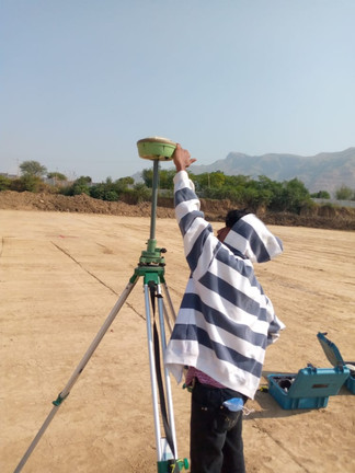

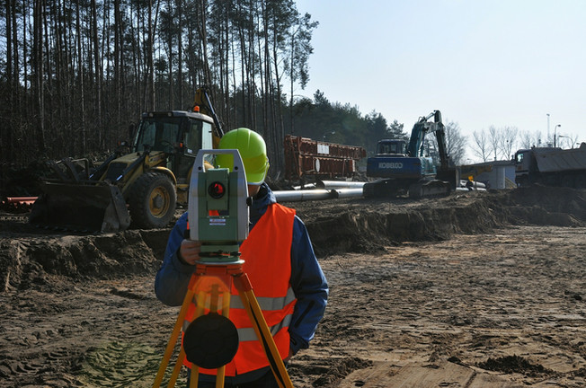
#GPS/#GNSS-#RTK or #TotalStation based topographic survey is in vogue as a conventional means to map the site. It gives an accurate positioning accuracy of 2 centimeters or less, sufficient to map the project site at a 1:100 scale. However, to conduct the survey, a surveyor needs one or more control points to start their survey. In the case of GPS/GNSS RTK, a surveyor has to establish a #benchmark for the base station. This benchmark is established by averaging a large GPS/GNSS dataset or through a local #datum. Some surveyors collect the 24 hours GPS/GNSS data at the site to process their benchmark coordinates in conformity with international terrestrial reference frame (#ITRF). It helps in recreating the benchmark if the site is demolished or deterred by any natural or man-made calamity. This step is an integral step in surveying to establish the local horizontal and vertical control points to control the accuracy of the survey.

Establishing a #benchmark for a total station can be followed as above or, previously, a surveyor chose their project site datum and assigned the first benchmark position as (0, 0, 0). It requires an extra step in transforming from the project site datum to a local grid and necessitates a permanent physical monument in the ground.

Both GPS/GNSS RTK and Total Station collect data point-wise. It means each point is to be recorded by the surveyor. Usually, an undeveloped land survey requirement is provided by the client. The client identifies the inter-distance between each point where a point is required to be collected (usually, 5m to 10m). Alternatively, a professional surveyor collects the data points according to his experience. He/she gathers a few points on relatively flatter land and acquires a large dataset on uneven surfaces to map the site accurately. This situation exacerbates when one uses Total Station where a surveyor has to take care of the inter-visibility of the equipment.
Therefore, conventionally, a large site requires a large crew with an extra RTK/Total Station equipment to record each part of the land parcel with every detail on the land. According to the probability, the more variables you add to an experiment (project in our case), the more chance you are taking it to go wrong (distributive law of sets). Moreover, the cost of the project also cannot be overlooked.

On the other hand, a #drone-based topographic survey requires comparatively fewer resources and provides a far better result. There are two methods of data collection in a drone-based topographic survey i.e., #photogrammetry and #LiDAR. In photogrammetry, geo-tagged photographs are captured to generate an #orthomosaic/#orthophoto and a digital elevation model (#DEM)of the site. Whereas, in a LiDAR-based survey, a 3D point cloud is generated by transmitting and receiving lasers from the drone (usually 200 points per sq meter). The horizontal and vertical survey accuracy is controlled by ground control points or accurately localized the drone through GNSS-based #RTK or #PPK.

In comparison with GPS/GNSS-RTK / Total Station, a drone-based survey provides higher data points per square meter and all the details of the project site. This level of detail cannot be acquired from conventional means of surveying. Secondly, an orthomosaic/orthophoto gives a context of different land features of the site to a designer/consultant to design efficiently and optimize resources. Usually, these outputs are decimated to convert in CAD format for consultants to estimate the construction quantities. Although a GIS software can also estimate the required quantities, pre-existing well-defined and proven methodologies necessitate the requirement of a CAD drawing file.

We cannot undermine the conventional means of surveying productivity for a smaller land or stakeout survey yet modern technologies like Mobile Mapping System (MMS) are overtaking the stakeout survey with improved productivity.
In conclusion, we can say that drone-based surveying technology provides improved productivity with comparable survey accuracy.
AZ NavTeq provides professional drone services for topographic survey, aerial inspection, and other geospatial and mapping services. For details, contact us at info@aznavteq.com.


Comments