
Writen by
aznavteq@gmail.com
In the dynamic landscape of surveying and mapping, drone-based photogrammetry has emerged as a transformative force, redefining precision and efficiency in data acquisition. At the forefront of this revolution is AZ NavTeq, pioneering drone-based surveying and mapping services that promise accuracy, speed, and a digital evolution of traditional CAD drawings.
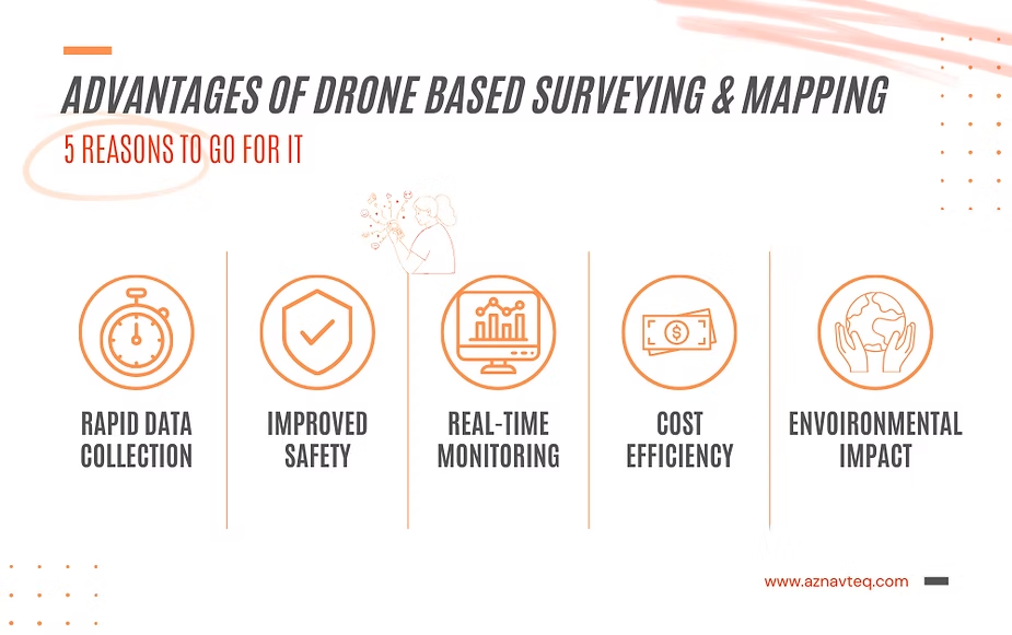
1. Rapid Data Collection:
- Drones cover large areas swiftly, collecting data at a pace that traditional surveying methods struggle to match.
2. Improved Safety Measures:
- Drone-based surveys reduce the need for personnel to physically access challenging terrains or hazardous sites, enhancing overall safety.
3. Real-Time Monitoring:
- Drones provide real-time data, enabling on-the-fly adjustments and immediate identification of potential issues.
4. Cost-Efficiency:
- The efficiency of drone-based surveys translates into cost savings, offering a compelling economic advantage over traditional methods.
5. Environmental Impact:
- With reduced need for ground vehicles and minimized site disturbance, drone-based surveying is more environmentally friendly.
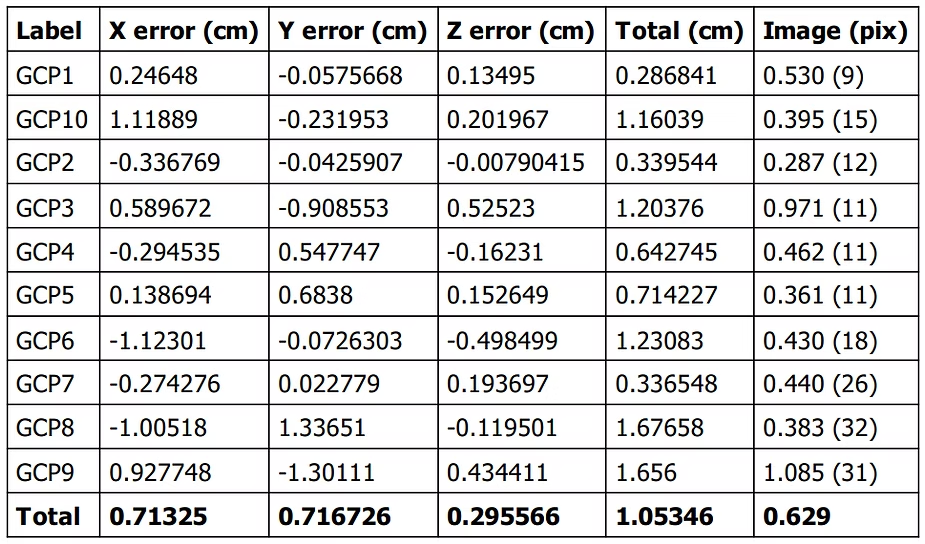
Unlocking Precision without Compromise: Drone-based surveying and mapping offer unparalleled accuracy, ensuring that topographic survey requirements are not just met but exceeded. The precision achieved through photogrammetry is a game-changer, providing data that serves as the backbone for meticulous CAD drawings.
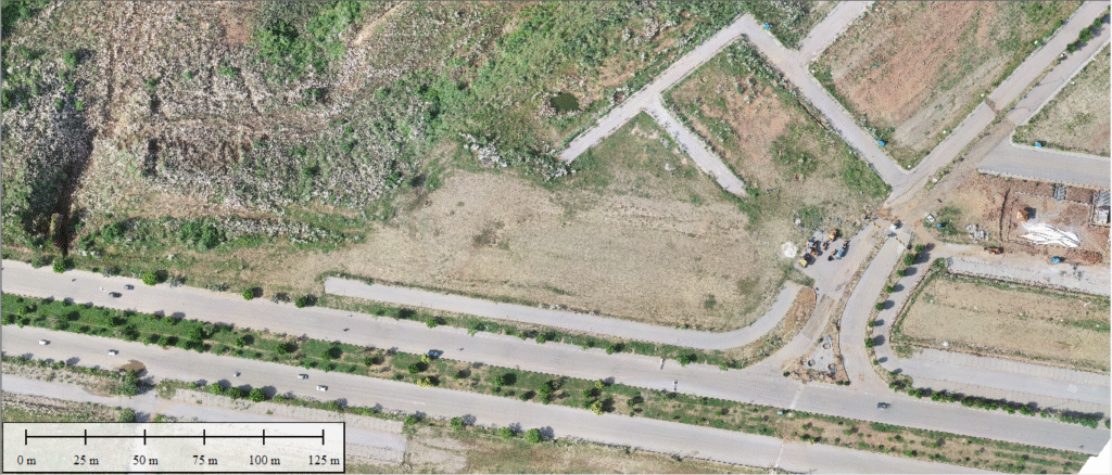
Digital Twin Creation: One of the standout features of drone-based surveying is the creation of a digital twin. The drone captures the site in intricate detail, allowing for the recreation of any missed information in CAD drawings with a few clicks. This not only reduces the need for revisiting the site but also minimizes logistics and accelerates turnaround time.
Reducing Logistics and Turnaround Time: Beyond the digital twin advantage, drone-based surveying significantly reduces the logistics involved in revisiting a site. The swift data collection process, combined with the ability to recreate elements digitally, accelerates the turnaround time for project completion.
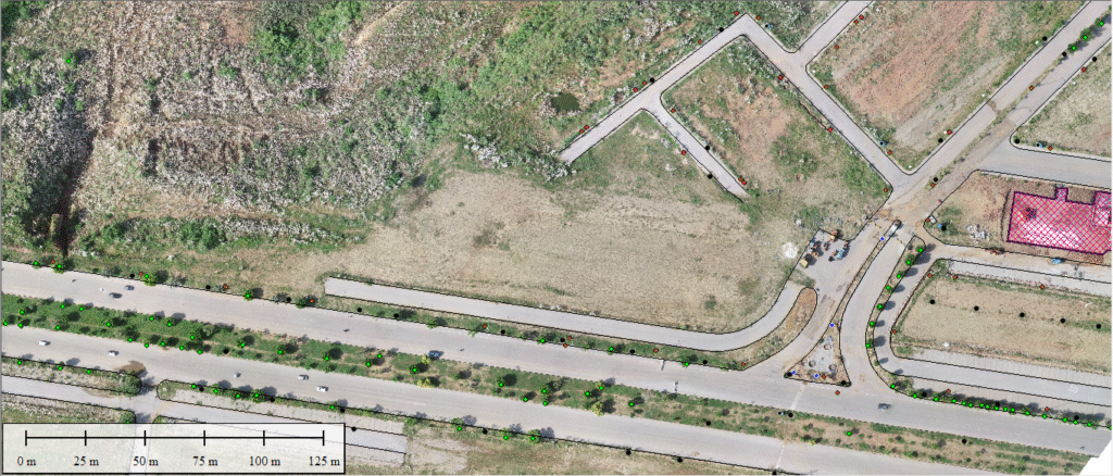
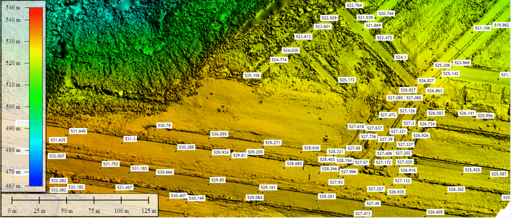
Enhancing Workflow with Orthomosaic and DEM: Drone-based deliverables, such as orthomosaic and Digital Elevation Models (DEM), are elevating end-users’ workflow. Unlike traditional reliance solely on CAD drawings, these spatially rich outputs provide a holistic view of the site. This spatial context proves invaluable in feasibility studies and design projects, fostering improved project planning and delivering superior final results.
AZ NavTeq’s Commitment: In the realm of emerging drone-based surveying and mapping services, AZ NavTeq stands out as a provider committed to client satisfaction and exceeding expectations. The company’s dedication to leveraging cutting-edge technology ensures that each project benefits from the precision and efficiency inherent in drone-based photogrammetry.

In conclusion, drone-based photogrammetry is not merely a technological advancement; it’s a paradigm shift in surveying and mapping. AZ NavTeq, as a trailblazer in this field, is reshaping the industry by providing solutions that go beyond traditional CAD drawings, creating a future where precision, efficiency, and spatial understanding converge seamlessly.