
An immersive VR experience built with photogrammetry
- Cool Yaar Pakistani
- Oct 18, 2024
- 4 min read


Tropical Jeju Island is a beloved tourist destination. Virtual reality is bringing it to an even wider audience.
Jeju Island is known for its pristine beaches, cascading waterfalls, and untouched forest.
15 million visitors flock to Jeju Island every year, touching down on 178 flights every single day. The tourists vastly outnumber the 660,000 people who call South Korea’s largest island home - but many more wish to visit.
Bringing the beauty of Jeju Island to even more people is Drone Orange Co, Ltd (also known as DO2). Based on Jeju Island, Drone Orange produces virtual reality, augmented reality and interactive media which allows visitors to experience the island in a whole new way.
Project details
Company Drone Orange
Location Jeju Island, South Korea
Hardware DJI Phantom 4 Pro drone
Software Pix4Dmapper
GSD 3.5 - 8cm
Outputs Jeju World Heritage VR flying simulator AR (augmented reality) program Realistic 3D printed miniatures VR (virtual reality) dioramas
360 video vs virtual reality
This project isn’t the first time Jeju Island has been shared with innovative technology. In 2016, the team developed the first Jeju flying simulator with a 360 degree video filmed with multiple cameras.
While the project was successful at the time, Drone Orange CEO Moses Jung says 360 degree videos have drawbacks compared to virtual reality, including:
A lower video quality
The 3D depth can appear too ‘shallow’
Viewers follow a fixed flying route which is less immersive
After looking at the technology, the team concluded that reconstructing the environment in Pix4D would be more successful than attempting to improve the 360 degree video.

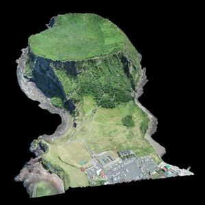
A digital twin of Korea’s highest mountain
Mt Hallasan is Korea’s highest mountain, a UNESCO World Heritage site, and one of the most popular attractions on Jeju Island. The Drone Orange team took on the challenge of reconstructing it in 3D.
Before flying their DJI Phantom 4 Pro drone, the team received permission from both the government and the Jeju World UNESCO Heritage Center.
Jung recalls: “Since Mt Hallasan is the highest mountain in Korea, the weather at the summit changes all the time. It took about six hours to get to the top of the mountain, with no guarantee of good weather once we got there.”


“Thankfully, the weather was fine, but we only were permitted to fly the drone for one hour - two hours max. Luckily, we managed to capture everything we needed!”
Other places, including the famous Seongsan Ilchulbong (Sunrise Peak) also posed a challenge.


Compass errors were a constant issue: “We assume the rocks in the area caused this and flew manually most of the time,” says Jung.
Poor weather also disrupted the flying schedule. But when the sun came out, so did the tourists. The Drone Orange team was only allowed to fly for an hour or two at a time to minimize disruption to visitors to Sunrise Peak.
The authorities kept a close eye on the drone activity as well. Much of Jeju Island is a UNESCO World Heritage area and the authorities wanted to ensure that no damage was done.
Combining the data
Pix4Dmapper is designed to make survey-grade maps and accurate 3D models. Creating an immersive VR experience is another process entirely.
Capturing the images took around two hours per site. The processing in Pix4Dmapper was completed in two days. It took seven months to deliver the project.

“We believe this pioneering project is the first in South Korea, and possibly the world,” says Jung. “What makes it unique is that so many technologies were used and merged together. We began with drone operating and then mapping, 3D point cloud and modeling in Pix4D, before polishing the mesh and moving to 3D Max/Z-Brush, UNITY realtime games engine, the VR program, and finally the motion simulator for riders, and 3D printing for the miniature.”
“If we had created the 3D models and triangle mesh from scratch, it would have taken us much longer than using Pix4D’s results. We never considered using any other software.”
“We hope this project proves that drone mapping tech can be applied to many other business and tech areas.”
Impressive technology, immersive experiences
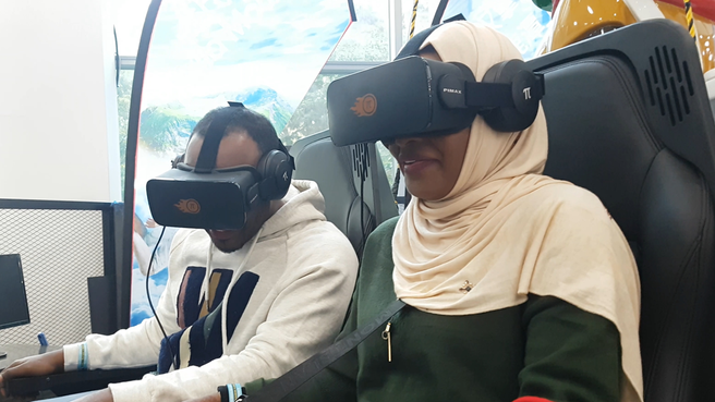
Drone Orange’s work can be experienced in Playbox VR in Jeju Island.
Thrillseekers can strap into a chair and fly over the island, taking in the sites from the skies, or ride a rocket-powered roller coaster over the island.


For those preferring a more sedate way of viewing the island, there are 3D printed models which can be enhanced with an AR overview. The models were created in Pix4Dmapper, before being 3D printed and painted by hand using the Pix4Dmodel project as reference.
Plus, 3D prints are available for visitors to take home and continue to explore.


Jung and the Drone Orange team hopes that Playbox VR will be a tourist attraction for years to come. As well as offering something different to the millions of visitors the island hosts every year, opening the island to people who may find it difficult to scale Mt Hallasan’s peak - or who just want to experience Jeju Island in a whole new way.
Source: Pix4D


Comments